Online Maps — Other Types of Geospatial Data in Geomashups
In addition to web tilesets, geomashups can also include KML files, Web Map Server Layers, and spatial data in Google Fusion Tables.
Click icons below map to open geomashups with:
 Google Maps
 Open Layers
 Google Earth
 Bing Maps
Geomashup of KML Files
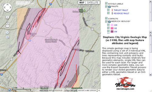
This simple geologic map is being displayed using a set of 3 individual KML files containing rock unit polygons and lines representing contacts and faults. Because this map includes relatively few geometric elements, single KML files can be used for each layer. For larger and more complex geometric data, you can use the Export Geometric Tileset process to render your styled geometric data to either a KML geometric tileset or an SVG geometric tileset. The TNTmips Assemble Geomashup process was used to assemble the 3 KML files, sidebar, and other features, including specifying legends for 2 of the KML layers. A legend entry is created for each unique style and corresponding attribute value in the source geometric object.
The map data were downloaded from a USGS web site as shapefiles, imported to TNTmips as vector objects, and styled to match the source map. TNTmips then converted the vector elements in each vector to styled elements in a KML file along with associated attributes set by element DataTips.
The TNTmips interactive Assemble Geomashup process was used to assemble the 3 KML files, sidebar with legend, and other features into this mashup. Moving the cursor over a map feature reveals the feature name; clicking on the feature opens an info window to show additional information.
Geomashups Using WMS Layers
Geomashups can include overlays displayed from remote Web Map Server (WMS) sites along with or instead of standard web tilesets. MicroImages has prepared several sample geomashups using WMS layers.
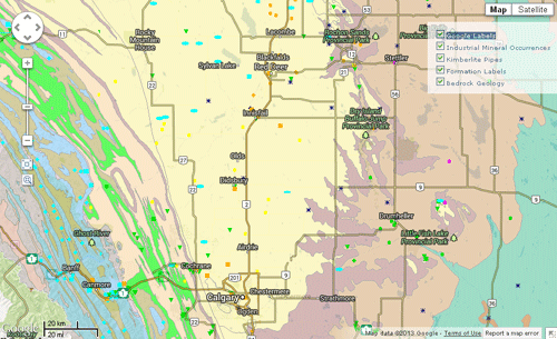
Alberta Geologic Map Data
These map layers hosted by the Alberta Geological Survey include a bedrock geologic map of the province (set here to be partially transparent), a separate layer with formation labels (which appear at higher zoom levels), points with labels showing locations of kimberlite pipes, and points showing industrial mineral occurrences.
Amazon Basin Land Cover
This geomashup has three mutually-exclusive layers hosted by the Amazonica Initiative in Brazil: land cover, biomass, and projected extent of deforestation in the year 2020.
City of Philadelphia
This mashup uses data hosted by Pennsylvania Spatial Data Access (PASDA). Two image layers are set here to be mutually exclusive: 2008 Land Cover (partially transparent) and a 2010 Orthoimage. Two additional overlays show the 2012 bike network and the outlines of recreation parks.
Geomashups Using Google Fusion Tables
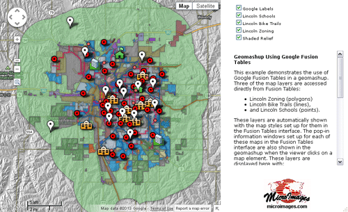
This example demonstrates the use of Google Fusion Tables in a geomashup. Three of the map layers are accessed directly from Fusion Tables:
- Lincoln Zoning (polygons)
- Lincoln Bike Trails (lines),
- and Lincoln Schools (points).
These layers are automatically shown with the map styles set up for them in the Fusion Tables interface. The pop-in information windows set up for each of these maps in the Fusion Tables interface are also shown in the geomashup when the viewer clicks on a map element. These layers are displayed here with:
- a standard web tileset (Shaded Relief)
- the proprietary Google Labels layer.
Any public Fusion Table map can be added to a Google Maps geomashup in combination with:
- standard web tilesets,
- SVG geometric tilesets,
- KML geometric tilesets,
- and KML files.
Map elements and their attributes in any TNTgis vector, CAD, or shape object can be exported to a Google Fusion Table using the Export process in TNTmips.