Geoprovisioning
Image provisioning using TNTscript
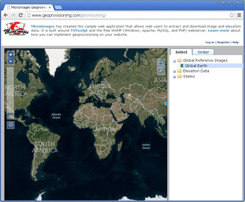
MicroImages has created a Geoprovisioning web application built using TNTscript and the free WAMP (Windows, Apache, MySQL, and PHP) webserver that allows web users to extract and download image and elevation data posted on a website. The application provides an interactive web interface to allow users to register, choose a dataset, designate an extraction area, and order the data. A geospatial processing script run under TNTscript handles the back-end image processing tasks in this application.
The downloadable provisioning system package includes the scripts, interface files, and instructions needed to set up a geoprovisioning system on your own website with a TNTscript license. You can edit the main provisioning page (PHP file) to customize the web interface.
You can allow provisioning from one or more images and/or elevation datasets. The provisioning application provides a web interface using WAMP that allows registered users visiting your provisioning website to select a dataset from which to extract, define the extraction area, and order the data. MySQL database tables are used to store information about the available data layers and user registration information. Each dataset you provide as an extraction source must be a raster object in a TNTgis Project File; this object can be a standard TNTgis raster or a tiled TNTgis raster linked to external tile files. PHP scripts are used to manage the web interface, start TNTscript, and pass the extraction information to an SML script that performs the extraction and sends an e-mail notification with download link to the user.
The Open Layers web interface uses Bing Maps aerial imagery as a default geographic reference for image selection. The area of each of the available image layers can be indicated in the browser view by a KML file containing a boundary polygon and/or by a web tileset that you prepare from your source image and post on your website. If neither of these is provided, a box indicating the rectangular geographic extents of the image layer is shown as an overlay on the Bing Maps imagery.
The Provisioning application has been developed and tested using WampServer 2.5, which includes the following components: Apache 2.4.9, MySQL 5.6.17, PHP 5.5.12, PHPMyAdmin 4.1.14, SqlBuddy 1.3.3, XDebug 2.2.5. Other versions of WAMP such as Uniform Server and XAMPP with similar component versions may also be used, but may require adjustments in the WAMP configuration.